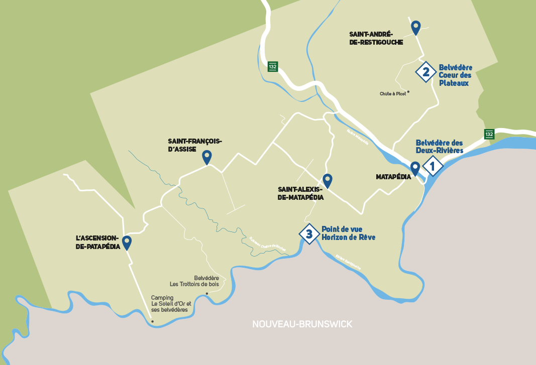
The Route des belvédères lookout construction project is growing in the Matapédia-et-les-Plateaux region. At the crossroads of the Baie-des-Chaleurs, the New Brunswick and the Matapédia Valley, this region forms the western part of the Avignon regional county municipality, in the southeastern part of the Gaspé. Regrouping the municipalities of Matapédia, Saint-André-de-Restigouche, Saint-Alexis-de-Matapédia, Saint-François-d’Assise and L’Ascension-de-Patapédia, this road is distinguished by its breathtaking landscapes of mountains and rivers.
1 – Deux-Rivières lookout
Is located at the top of a cliff overlooking the municipality of Matapédia.
2 – Coeur des Plateaux lookout
Sits on one of the highest points of the region.
3 – Horizon de Rêve
Horizon de Rêve future lookout, accessible free of charge via a 1 km round-trip trail with a view of the Restigouche River.
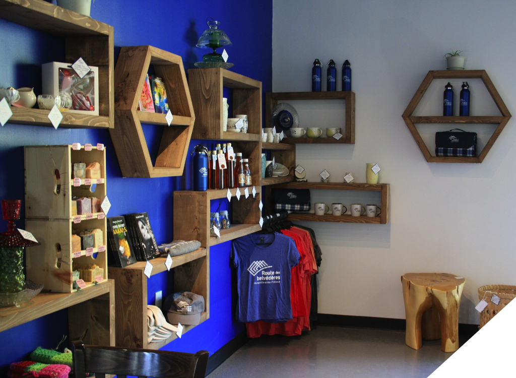
Carrefour d’accueil
Poirier Building – 4C Perron Est Boulevard, Matapédia
There, you will find information on the current lookouts, directions, information on the entire Route des belvédères project and on the future structures, etc.
Note that the Route des belvédères promotional items will return in the summer of 2024.
Summer schedule: the lookouts are open from sunrise to sunset. The Carrefour d’accueil is open every day from 9 a.m. to 5 p.m.
*Dogs on leash are allowed on the trails
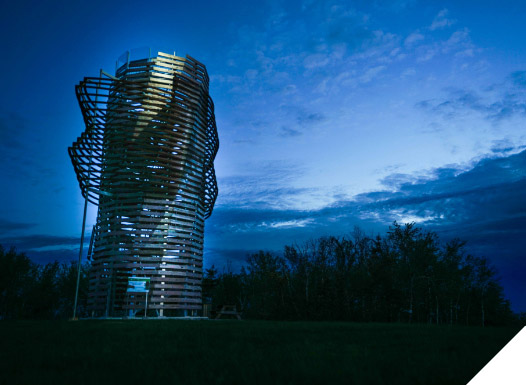
Deux-Rivières Lookout
MATAPÉDIA
The Deux-Rivières lookout is located at the top of a cliff overlooking the municipality of Matapédia. Once you have reached the end of one of the two trails leading to it, you will see the intriguing entrance of a twisted tunnel of which you cannot see the end. This tunnel is formed by a juxtaposition of squares made of wooden planks, between which openings allow light to filter through while revealing glimpses of landscape. At the very end of it, it opens offering a spectacular view of the confluence of the Matapédia and Ristigouche rivers.
How to get there
360 m steep trail The access trail is also the beginning of the International Appalachian Trail located in front of 4-C Perron Est Boulevard in Matapédia (pharmacy). After a 360 m steep ascent, you will reach the Deux-Rivières lookout.
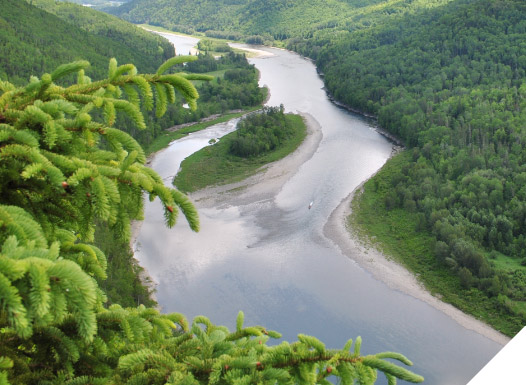
Located in Saint-André-de-Restigouche, the Cœur des Plateaux lookout sits on one of the highest points of the region. Inside a twisted tower of wood and metal, you will be invited to climb a spiral staircase that lets in light and landscape strips. From the top, a platform offers a 360° view of the bucolic agricultural panorama, allowing you to see up to 100 km away on a clear day.
How to get there
From Route 132, on the west side of Matapédia, take Rang Lagacé towards Saint-André-de-Restigouche. After 7.6 km, park your vehicle on the side of the road near the sign announcing the lookout, then walk 480 m along the trail on the right side of the field to reach the lookout. Climb the 60 steps inside the tower to access the platform at the top of the Coeur des Plateaux Lookout.
As part of the Route des belvédères project, the current structure will be replaced by a new structure with a distinctive architecture. The Horizon de rêve lookout in Saint-Alexis-de-Matapédia offers a magnificent view of the Restigouche River from an altitude of 300 m.
This site uses cookies for the purposes of obtaining statistics and marketing while allowing you an optimal browsing experience.
Fonctional
Always active
The storage or technical access is strictly necessary for the purpose of legitimate interest of allowing the use of a specific service explicitly requested by the subscriber or user, or for the sole purpose of carrying out the transmission of communication on an electronic communications network.
Preferences
Storage or technical access is necessary for the purpose of legitimate interest to store preferences that are not requested by the subscriber or user.
Statistics
Storage or technical access that is used exclusively for statistical purposes.Storage or technical access that is used exclusively for anonymous statistical purposes. Absent a subpoena, voluntary compliance by your Internet Service Provider, or additional records from a third party, information stored or retrieved for this sole purpose cannot generally not be used to identify you.
Marketing
The storage or technical access is necessary to create user profiles in order to send advertisements, .or to follow the user on a website or on several websites with similar marketing purposes.